
October-ganza 23: The Ghost of the Swift River
Leave a commentOctober 23, 2014 by Bret Kramer (aka WinstonP)
Traces of the old one can still be found amidst the weeds of a returning wilderness, and some of them will doubtless linger even when half the hollows are flooded for the new reservoir. Then the dark woods will be cut down and the blasted heath will slumber far below blue waters whose surface will mirror the sky and ripple in the sun. And the secrets of the strange days will be one with the deep’s secrets; one with the hidden lore of old ocean, and all the mystery of primal earth.
– The Colour Out of Space
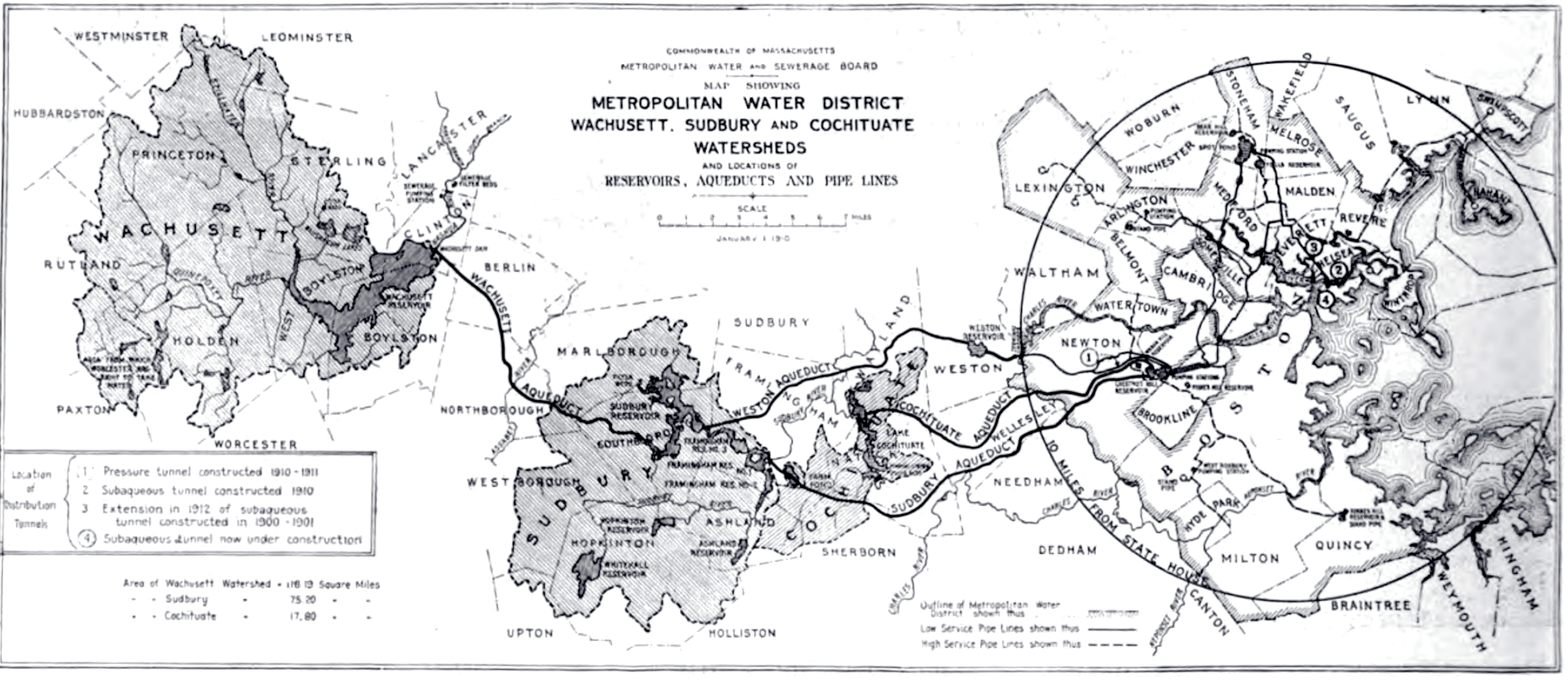 The Quabbin Reservoir was the final (so far) civil engineering project to secure a reliable supply of clean water for Boston. The drive to create a series every larger reservoirs for Boston had begun even before the Civil War, with the construction of the Cochituate Aqueduct in 1846, followed by the Sudbury Reservoir in 1878, and then the Wachusett Reservoir in 1908. This last project was by far the largest, creating the then largest body of freshwater in Massachusetts and displacing much of the town of West Boylston, causing a great outcry among the town’s residents, with little impact on the state government.
A similar project was undertaken in Rhode Island a few years later, with the construction of the Scituate Reservoir beginning in 1921. There was ever more fierce opposition to this project, one family going so far as to burning their house down and possibly take their own lives (the sources for the later part are rather poor).

Enfield, 1927
As early as the 1920s planning began on an even larger project, the largest human-made drinking water reservoir to date, one that would dwarf all of those that came before. The site selected in 1922 was the Swift River valley, a rural section of central Massachusetts. In 1920 the four towns of the designated section had a population of just over 2000; Boston’s population was nearly 750,000. In 1926 the state began to pass legislation to fund the project and obtain the necessary land and one by one, the towns of the Swift River valley began to empty.

Site of Enfield, 1939
An enormous aqueduct connecting the future site of the reservoir (officially named “Quabbin” in 1932 for the old Nipmuc name for the region meaning “the meeting of many waters”) to the Wachusett Reservoir was completed in 1933. Land clearing begins in 1936, with the whole of the valley to ’10 above the projected water level of the new reservoir denuded. In 1938 the four towns are officially dis-incorporated, with the building being either demolished or relocated elsewhere. The project of completely filling the reservoir takes seven years (from 1939 to 1946). This PDF has a helpful timeline and illustrations.

Quabbin Reservoir, 1987
Today most of the reservoir is a restricted area, though some recreational use is permitted. The Prescott Peninsula, a long low ridge that bisects much of the Quabbin, was used for target practice by the Army Air Force during WWII and a radio astronomy observatory (now closed) was established there by the Five Colleges in 1969 due to its isolation.
In addition to the more than 2000 residents who had to be relocated, more than 7000 graves had to be relocated from over 30 burial sites. If living relatives, such as could be found, were given the choice to either rebury the bodies in a preferred cemetery or they could be moved to the new Quabbin Cemetery in Ware. Here are some photographs of said cemetery.
(Lovecraft visited the region in 1928 as part of a trip to Athol, a town north of the future site of the Quabbin, though I sadly lack his collected letters and cannot add more beyond that.)
The lost Swift River valley and its four vanished towns are now a part of local folklore. There is historical society as well as a volunteer organization dedicated to the historical and ecological importance of the Quabbin. There is also a rather extensive travel blog about the many sites in and around the Quabbin.
Enjoy your water, Boston.
